| Caribbean Marine Weather | |||
|
|
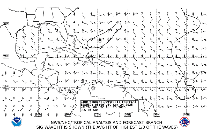
Offshore Waters Southwest &Tropical N. Atlantic & Caribbean Sea Eastern Caribbean (Western Tropical Atlantic) (45W to 70W / 8N to 22N) Enhanced Infrared satellite image, hi-resolution animation, 25 images at 30-minute intervals, past 12 hrs. Requires Java. Slow to load but really good. Infrared pictures show cloud toptemperatures and make low level clouds harder to pick out. Try combining them with the geostationary satellite server visual image for a sharper view of low level cloud. Geostationary East visual image Good live Hurricane Information from local posters The Compass, the free magazine for the Caribbean cruiser, keeps this list reasonably current. Eric (9ZCP) 6:30 AM AST 3855 LSB George (KP2G) 7:00 AST 7250 LSB for the Caribbean Maritime Net. (Formerly operating at 7.241Mhz) Switches to 7086 LSB @ 7:30 AST. Also on afternoon Cocktail and Weather net at 7086 @ 4:30AST |
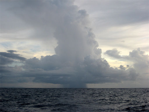
Caribbean weather seems both dramatic and very different to this Californian who is used to a weather report that varies very little from day to day. Most days are marked by intense sunshine with little cotton ball clouds (fair weather cumulous) drifting lazily to the west. The skies are often dramatic with cumulonimbus clouds stretching far into the sky. Such clouds are dark at the top and very very tall and they often carry a long dark curtain of rain trailing down from them. If you can't avoid them, roll up the jib and reef the main until they pass for they are squalls and it can be quite windy (as well as torrentially rainy) in them. The winds in the Eastern Caribbean are typically easterly unless bent by lows and highs in the region. The direction of the wind will be generally parallel to the isobars found on the synoptic charts such as you see here. The typical pattern is for stronger winds to come more from the north east and more parallel to the isobars and weaker winds from south of east and more across the isobars.
The higher the pressure gradient will usually means the stronger the winds. The weather broadcaster will usually use the terms "light" - which means no sailing except for the lightest craft., "light to moderate" or "moderate" which is a typical trade wind and great for sailing, or "fresh" which means hold on to your hat and underwear (rather like sailing out under the Golden Gate on a hot summer afternoon). Of course local phenomena will always override these general predictions. If you have a tropical wave or other low near by, the wind will swing back and forth as the low passes.
Other non-barometric phenomena are notorious winds around near headlands (compression acceleration ala Bernouli) as you approach an island in the passage and winds that roar down the hills like water running over a rock in a rushing st ream.. Probably the best example of such a compression zone is Deshais at the northwestern end of Guadaloupe where I have hidden for days in winds of the harbor which had nothing to do with the very light gradient winds just outside. If you leave in the morning in light to moderate winds, reef the sails a few miles off the headlands of your next landfall. Probably the best example of Katabatic winds caused by cold air sliding down the fairly high peaks common in the islands can also make for a surprisingly windy anchorage (such as Pointe 'a Pitre in Guadeloupe) when the wind in open water is mild. Some of these phenomena are working on a continental scale off the Columbian coast where acceleration adds 10 knots to the wind forecast for the rest of the Caribbean (usually "south of 15 west of 75 West"). The winter pattern is periods of stronger ("enhanced") trade winds associated with highs moving east off the Florida coast followed by shorter periods of lighter winds associated with lows. The weather speculator will give the position and strength of these highs which will generally control the strength of the enhanced winds. Higher pressure, closer by and no intervening features to block the air flow and, voila, it blows. The winds in winter will generally be North Easterly and even in the absence of special features, stronger than summer winds. The summer pattern is typically of lighter winds generally more south of east. Summer, however, is hurricane season (generally June through November). Those with boats in the area keep anxious watch of charts and satellite images for a "Tropical Wave" (kind of a small inverted V trough stretching north above the equator, sometimes visible in the cloud images) traveling westward from the Sahara. These "tropical waves" seem to move at a fairly predictable pace and bring lots of rain and strong winds proportionate with the strength of the low. Given the right conditions (absence of wind shear among others), these can develop into strong cyclonic storms. To lessen the anxiety, plot the location of theses waves on a chart like this (gif) or this (pdf) as they move west..As they strengthen and become more organized, you will have already formed an impression of their speed and track. Needless to say, if such a wave turns into a hurricane - seek shelter and get off the boat.
If I am concerned about the weather because I'm planning a passage or it is hurricane season, I use an amateur's approach which works for me. I will get up at the same time (generally about 6:00) and as part of the morning coffee ritual note down the pressure in a little day timer style calendar I keep for the purpose on the nav station. Is it rising or falling? Poking the head out the hatch, I'll gain an impression of what wind and clouds are like and make coffee. At 6:30 I tune in Eric (9Z4CP) for his take on the weather. When he reads the "Offshore waters report", I will make a note on that days page on the left side of the box, I note the forecast for the "CARIBBEAN SEA AND TROPICAL N ATLC FROM 7N TO 22N BETWEEN 55W AND 65W" and, on the right side of the box, the forecast for "E CARIBBEAN E OF 75W TO LEEWARD AND WINDWARD ISLANDS". I do this in a kind of self developed shorthand that looks something like this
At 7:15 I listen to the same thing from George (KP2G) and see if I or anyone else has gotten it garbled. As the days go by, I switch ink colors and just write in the new forecast below the previous one for that day. If they seem stable, I give them some credence. If I notice that the one above is wildly different from the one I'm writing, I figure things are weird and only the 24 hour forecast will have much value and I will rely more on looking outside and tell everyone I have no clue what the weather is. Generally, I'm only interested in the wind strength and direction. (It is more pleasant to have the wind from off the bow). If it has been blowing a long while, the seas will be high short and steep. I don't really care about swells because the boat rides up and down them comfortably - although I may care for some anchorages are roily in swells from certain directions. Rain? It might rain on you at just about any time and place but it is warm so who cares? |
|||||
|
||||||