|
|
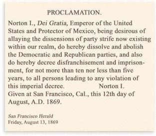
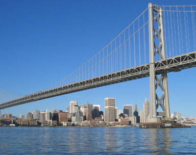 The San Francisco Bay Bridge is one of the few decree's of Norton I, Emperor of North America and Protector of Mexico (popularly called Emperor Norton) which actually came to fruition. The mandate that "San Francisco Bay be bridged immediately" was fulfilled long after the emperor and his two dogs, Bummer and Lazarus were gone. The Bay Bridge is the longest steel high-level bridge in the world and its construction required the greatest expenditure of funds ever used for a single structure in the history of man. The deeper pier which was sunk at 242 feet below water is bigger than the largest of the Pyramids and required more concrete than the Empire State Building. The bridge was opened to traffic on Thursday, November 12, 1936 and was built in three years four months and three days. Wrangling over earthquake strengthening and replacement of the eastern span have taken a lot longer than that and despite staggering and rising expenditures, will not be completed soon. The San Francisco Bay Bridge is one of the few decree's of Norton I, Emperor of North America and Protector of Mexico (popularly called Emperor Norton) which actually came to fruition. The mandate that "San Francisco Bay be bridged immediately" was fulfilled long after the emperor and his two dogs, Bummer and Lazarus were gone. The Bay Bridge is the longest steel high-level bridge in the world and its construction required the greatest expenditure of funds ever used for a single structure in the history of man. The deeper pier which was sunk at 242 feet below water is bigger than the largest of the Pyramids and required more concrete than the Empire State Building. The bridge was opened to traffic on Thursday, November 12, 1936 and was built in three years four months and three days. Wrangling over earthquake strengthening and replacement of the eastern span have taken a lot longer than that and despite staggering and rising expenditures, will not be completed soon.
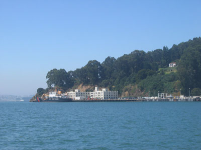 The island at the middle of the San Francisco Bay Bridge through which the tunnel is bored, is now called "Yerba Buena". It has been known as Seabird Island, Wood Island and Goat Island. Along about 1836, Captain Gorham Nye was responsible for the name which clung for many years, having placed goats on it for sale to trading vessels.The first legislature of California on February 18, 1850, passed an act establishing the limits of San Francisco County and gave the island the name of Yerba Buena which is how it was known to the Spanish. Officially the island was Yerba Buena until about 1895, when, upon the authority of a decision of the U. S. Geographic Board, it was changed to Goat Is land.. In 1931 the old Spanish name was restored. John J. Cameron, secretary of the board announced the decision that concluded a long series of demands for the change. "We were reluctant to change the name," Cameron said, "because there must be stability, and the name Goat Island was officially adopted in 1895. We are convinced, however, that the people have now made up their minds to use the old Spanish name. The decision was unanimous." Yerba Buena, Spanish for "good herb", was the name applied to an aromatic little trailing vine, sometimes called California mint, and because it covered the slopes of the island, it was common usage for the island. The island at the middle of the San Francisco Bay Bridge through which the tunnel is bored, is now called "Yerba Buena". It has been known as Seabird Island, Wood Island and Goat Island. Along about 1836, Captain Gorham Nye was responsible for the name which clung for many years, having placed goats on it for sale to trading vessels.The first legislature of California on February 18, 1850, passed an act establishing the limits of San Francisco County and gave the island the name of Yerba Buena which is how it was known to the Spanish. Officially the island was Yerba Buena until about 1895, when, upon the authority of a decision of the U. S. Geographic Board, it was changed to Goat Is land.. In 1931 the old Spanish name was restored. John J. Cameron, secretary of the board announced the decision that concluded a long series of demands for the change. "We were reluctant to change the name," Cameron said, "because there must be stability, and the name Goat Island was officially adopted in 1895. We are convinced, however, that the people have now made up their minds to use the old Spanish name. The decision was unanimous." Yerba Buena, Spanish for "good herb", was the name applied to an aromatic little trailing vine, sometimes called California mint, and because it covered the slopes of the island, it was common usage for the island.
The current construction has turned up evidence that the native Indians had traveled to the island, probably on tule boats, to hold conferences. A tribe of Indians known as the Tuchayunes are accredited with having occupied the island as a fishing station. There is the tale told of the arrival in San Francisco Bay, on July 6th, 1849, of the ship "Edward Everett", with one William Bernard aboard (afterward more familiarly known as "Barnacle Bill"). On the following day, accompanied by a man named Phelps, "Barnacle Bill" landed on the island. They found no person inhabiting it, and nothing alive except a few goats.On the eastern shore, they found the remains of an extensive Indian village. There were ruins of old houses and a vast collection of bones and shells as well as the cremating pits where the aborigines of the bay burned their dead. After a few days on the island, the two men left for the Oakland shores, and later, the mines, so they were not among those who later claimed the island, although Bernard returned to live on it for a time.
Aside from pleasure excursions, the Island saw little use until In 1868, when peremptory orders came from Washington for the occupation of Yerba Buena Island in force and a detachment of 125 men of the Engineer Corps, stationed at Point San Jose, was ordered transported to the island. There had been activity on the part of the Central Pacific Railroad and its sympathizers to obtain the island as a railroad terminus and feeling had run high between the factions and their divided interests. This government order for military occupation was understood as settling negatively all claims for the occupation of the island for railroad purposes. The military reservation was used as a Quartermaster depot from 1871 to 1892, being transferred to the U. S. Engineer Department in the latter year. As with most lands declared a potential use as a fort, the Island became government property.
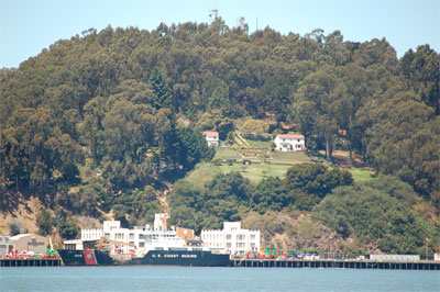 On April 13, 1898, Congress made an appropriation for the establishment of a Naval Training Station for apprentices on the Pacific Coast and President McKinley set aside for that purpose, a portion of Yerba Buena Island. Prior to the erection of barracks and other buildings, the apprentices lived aboard the U. S. S. Pensacola, anchored alongside, and later secured to, the island, It carried 175 cadets between the ages of 15 and 17, besides the ship's crew. During the world war there were, at one time, 13,000 men under training on the island. Navy activities on the island, following the removal of the training station, are those of conducting the Receiving Ship. The old U. S. S. Boston, famous as one of Dewey's fleet at the Battle of Manila Bay, is moored to the short dock on the east side of the island. This, officially, is the "Receiving Ship", although all of the business of the Receiving Ship is conducted ashore in the administration building. On April 13, 1898, Congress made an appropriation for the establishment of a Naval Training Station for apprentices on the Pacific Coast and President McKinley set aside for that purpose, a portion of Yerba Buena Island. Prior to the erection of barracks and other buildings, the apprentices lived aboard the U. S. S. Pensacola, anchored alongside, and later secured to, the island, It carried 175 cadets between the ages of 15 and 17, besides the ship's crew. During the world war there were, at one time, 13,000 men under training on the island. Navy activities on the island, following the removal of the training station, are those of conducting the Receiving Ship. The old U. S. S. Boston, famous as one of Dewey's fleet at the Battle of Manila Bay, is moored to the short dock on the east side of the island. This, officially, is the "Receiving Ship", although all of the business of the Receiving Ship is conducted ashore in the administration building.
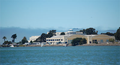
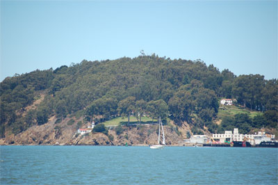 The acreage of the island is shared by three branches of the government service, there being 29.9 acres on the southeastern point given over to the United States Lighthouse Service; 11. 1 acres are assigned to the Coast Artillery Corps of the United States Army as a mine depot on the northeast point, and the remaining 107.3 acres is the portion assigned to the United States Navy as the Receiving Ship. The lighthouse, established in 1875, is not a large one but before the days of radio beacons and sirens, it was considered one of the most important lights on the coast. It is so located as to be in line with the now defunct Fort Point and Point Bonita, and was valuable to mariners entering the Golden Gate by these bearings. The original coal oil lamp of shiny brass, whose prismatic globe amplified its rays for service is still kept at the lighthouse. The station is equipped with all the automatic devices of modern times including graphs electrically traced to leave their indisputable records. The buoy wharf and lighthouse depot take care of supplies for all lights and buoys of the 18th Division, which includes all those on the west coast from the Oregon line to Mexico. They number in the thousands and conform as occasion demands to various sizes and types The acreage of the island is shared by three branches of the government service, there being 29.9 acres on the southeastern point given over to the United States Lighthouse Service; 11. 1 acres are assigned to the Coast Artillery Corps of the United States Army as a mine depot on the northeast point, and the remaining 107.3 acres is the portion assigned to the United States Navy as the Receiving Ship. The lighthouse, established in 1875, is not a large one but before the days of radio beacons and sirens, it was considered one of the most important lights on the coast. It is so located as to be in line with the now defunct Fort Point and Point Bonita, and was valuable to mariners entering the Golden Gate by these bearings. The original coal oil lamp of shiny brass, whose prismatic globe amplified its rays for service is still kept at the lighthouse. The station is equipped with all the automatic devices of modern times including graphs electrically traced to leave their indisputable records. The buoy wharf and lighthouse depot take care of supplies for all lights and buoys of the 18th Division, which includes all those on the west coast from the Oregon line to Mexico. They number in the thousands and conform as occasion demands to various sizes and types
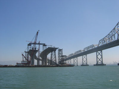 The East Span of the San Francisco Bay Bridge suffered a broken link in the Loma Prieta Earthquake and has since been deemed unsafe. After considerable political wrangling largely fueled by the general Bay Area dislike of Caltrans and the common feeling that Oakland gets the shorter end of every stick, an ambitious self-stayed, single tower design has been settled on for the deep water channel of the eastern span. The construction of this dramatic span has proven to be increasingly complex and expensive as the structure's suspension cables will not be anchored at either end (like the Golden Gate, Antioch or Western Span) but rather held out by the weight and compression strength of the roadway itself. This should work well once the roadway is in place but a temporary bridge will have to be constructed to hold up the roadway while it is being completed. This essentially makes for construction of a bridge to hold up the new span which will then be taken away when the new span is completed. In contrast, most suspension bridges build the tower and then anchor points at either end. The cable is spun in place and roadway sections are hung from the cable, a much cheaper process and one which was employed at the new Carquinez Bridge to lovely effect. Adding to the expense and trouble is the need to keep traffic flowing during construction. The East Span of the San Francisco Bay Bridge suffered a broken link in the Loma Prieta Earthquake and has since been deemed unsafe. After considerable political wrangling largely fueled by the general Bay Area dislike of Caltrans and the common feeling that Oakland gets the shorter end of every stick, an ambitious self-stayed, single tower design has been settled on for the deep water channel of the eastern span. The construction of this dramatic span has proven to be increasingly complex and expensive as the structure's suspension cables will not be anchored at either end (like the Golden Gate, Antioch or Western Span) but rather held out by the weight and compression strength of the roadway itself. This should work well once the roadway is in place but a temporary bridge will have to be constructed to hold up the roadway while it is being completed. This essentially makes for construction of a bridge to hold up the new span which will then be taken away when the new span is completed. In contrast, most suspension bridges build the tower and then anchor points at either end. The cable is spun in place and roadway sections are hung from the cable, a much cheaper process and one which was employed at the new Carquinez Bridge to lovely effect. Adding to the expense and trouble is the need to keep traffic flowing during construction.
 Treasure Island is the flat, man-made island to the north of Yerba Buena Island. It was one of the great projects or the New Deal Works Progress Administration. Business sponsors in San Francisco scraped together $760,780 in to match the $3,800,000 allocated by the WPA for an airport. to help launch the world exposition. . The ultimate plan was for this to be the San Francisco Airport with 4000 foot runways, two hangars and an administration did get built and remained after the fair but WWII intervened, the island became navy property and the airport was ultimately built south of the city on the peninsula. Treasure Island is the flat, man-made island to the north of Yerba Buena Island. It was one of the great projects or the New Deal Works Progress Administration. Business sponsors in San Francisco scraped together $760,780 in to match the $3,800,000 allocated by the WPA for an airport. to help launch the world exposition. . The ultimate plan was for this to be the San Francisco Airport with 4000 foot runways, two hangars and an administration did get built and remained after the fair but WWII intervened, the island became navy property and the airport was ultimately built south of the city on the peninsula.
 The shallows north of Yerba Buena Island were in places only a few feet below the surface and barges brought dredging from Presidio Shoals, Alcatraz Shoals and Knox Shoals. 287 000 tons of bolders were barged in to create the three mile perimeter breakwater around the island. The island was finished just months before the two big bridges were completed and a spectacular fair was planned to honor their construction. The two year run of the San Francisco Golden Gate Exhibition of 1939-1940 was, by all reports, one of the best parties the city has ever seen, this in a city known for massive bacchanals. The shallows north of Yerba Buena Island were in places only a few feet below the surface and barges brought dredging from Presidio Shoals, Alcatraz Shoals and Knox Shoals. 287 000 tons of bolders were barged in to create the three mile perimeter breakwater around the island. The island was finished just months before the two big bridges were completed and a spectacular fair was planned to honor their construction. The two year run of the San Francisco Golden Gate Exhibition of 1939-1940 was, by all reports, one of the best parties the city has ever seen, this in a city known for massive bacchanals.
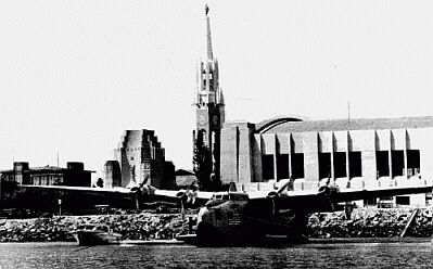
The hall of Air Transportation was the simplest, most successful exhibit on Treasure Island. A hangar where transpacific planes were fueled and groomed for flights to the Orient. Pan Am began regular flights from the Bay Area in late 1935. In 1939 five new Boeing 314 Flying Boats were put into service and based at Treasure Island. They were known as Flying Clippers and the ramp from their hangar was here in Clipper Cove. 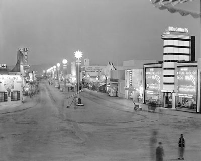 The island (and cove) did not exist at the time of the clipper ships. More fantastic buildings clearly showed the influence of Cambodia, Malasia, Siam as well as Mayan and Incon America. Huge statues surrounding the Tower of the Sun represented Science, Agriculture, Industry and Art. Tropical orchids, hibiscus and datura as well as the signature palm trees were nursed months before the fair in electrically heated plant beds in a city plant hospital. 4,000 trees, 70,000 shrubs and 700000 blooming plants were sustained by a 3,000,000 gallon reservoir which was hollowed out in the rock of Yerba Buena island. Electric lights were lavishly used throughout the island but never more so in the (I kid you not) "Gayway" pictured here. The uplifting and enlightening exhibits where largely forgotten by those who attended as children. However, few forgot the Gayway which was described as "Forty Acres of Fun". It featured over 50 exhibits and concessions, including carnival rides, shooting galleries, the Ripley's Believe It or Not Odditorium, burlesque shows, and an automobile racetrack for monkeys.For the men, Sally Rand Nude Ranch featured women wearing cowboy hats, gunbelts and boots (and little else). Other flesh shows included Candid Camera which featured live, nude models and an attraction called Greenwich Village which was described by the Official /Guide Book as "model artists' colony and revue theatre. For more about the Expo, click here or here. The island (and cove) did not exist at the time of the clipper ships. More fantastic buildings clearly showed the influence of Cambodia, Malasia, Siam as well as Mayan and Incon America. Huge statues surrounding the Tower of the Sun represented Science, Agriculture, Industry and Art. Tropical orchids, hibiscus and datura as well as the signature palm trees were nursed months before the fair in electrically heated plant beds in a city plant hospital. 4,000 trees, 70,000 shrubs and 700000 blooming plants were sustained by a 3,000,000 gallon reservoir which was hollowed out in the rock of Yerba Buena island. Electric lights were lavishly used throughout the island but never more so in the (I kid you not) "Gayway" pictured here. The uplifting and enlightening exhibits where largely forgotten by those who attended as children. However, few forgot the Gayway which was described as "Forty Acres of Fun". It featured over 50 exhibits and concessions, including carnival rides, shooting galleries, the Ripley's Believe It or Not Odditorium, burlesque shows, and an automobile racetrack for monkeys.For the men, Sally Rand Nude Ranch featured women wearing cowboy hats, gunbelts and boots (and little else). Other flesh shows included Candid Camera which featured live, nude models and an attraction called Greenwich Village which was described by the Official /Guide Book as "model artists' colony and revue theatre. For more about the Expo, click here or here.
World War II interrupted plans for the airport and the city sold the island for one dollar to the navy. It became Treasure Island Naval Station. Recently the City of San Francisco again regained possesion of the island as the Navy moved all its operations out of the SF Bay in favor of Bremerton Washington. .
|
 |