|
|
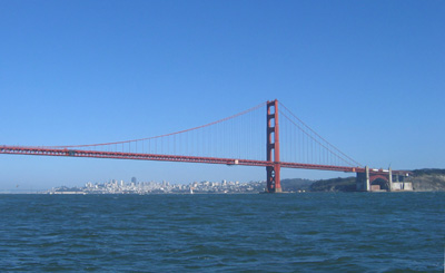
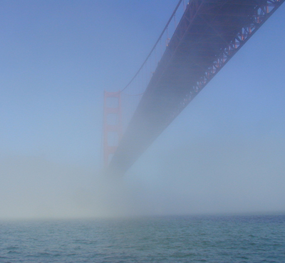 The Golden Gate Bridge is not golden at all, but rather a kind of rust red. The famous bridge spans the "Golden Gate", the name of the entrance to the San Francisco Bay. Due to the Humbolt current which flows south from Alaska, the water outside the Gate is very cold, usually in the low to mid 50 degrees. Just inside the Gate, along the great San Juaquin/Sacramento river delta, is air heated every summer afternoon to over 100 degrees. This warm air rises and draws the cold moist air in providing San Francisco sailors with reliable winds in the 20+ knot range (Beaufort 6).The cold offshore marine level produces a pretty solid fog outside the bay. In fact, it is fascinating to stand at the northern landing of the bridge where the moist air rises over the bluff and watch the moisture condense out of the air. This fog was so well known that the area inside the Farallon Islands was avoided by the old sailors and was marked on the maps as the "Gulf of the Farallons". The Bay was finally discovered from land. On November 4, 1769 when Spanish explorer Gaspar de Portolà, was unable to find the major port of California at Monterey, he moored his ship close to what is now Pacifica. Short on water and food, Portolà and an expeditionary crew of 63 men and 200 horses began an overland journey that took them to the summit of the 1200 foot high Sweeney Ridge (in San Mateo County), where he sighted the San Francisco Bay .Monterey basically is the other way. He also had the distinction of piloting the first of over 165 ships to be wrecked when he bumped a rock as he exited in 1775. The Golden Gate Bridge is not golden at all, but rather a kind of rust red. The famous bridge spans the "Golden Gate", the name of the entrance to the San Francisco Bay. Due to the Humbolt current which flows south from Alaska, the water outside the Gate is very cold, usually in the low to mid 50 degrees. Just inside the Gate, along the great San Juaquin/Sacramento river delta, is air heated every summer afternoon to over 100 degrees. This warm air rises and draws the cold moist air in providing San Francisco sailors with reliable winds in the 20+ knot range (Beaufort 6).The cold offshore marine level produces a pretty solid fog outside the bay. In fact, it is fascinating to stand at the northern landing of the bridge where the moist air rises over the bluff and watch the moisture condense out of the air. This fog was so well known that the area inside the Farallon Islands was avoided by the old sailors and was marked on the maps as the "Gulf of the Farallons". The Bay was finally discovered from land. On November 4, 1769 when Spanish explorer Gaspar de Portolà, was unable to find the major port of California at Monterey, he moored his ship close to what is now Pacifica. Short on water and food, Portolà and an expeditionary crew of 63 men and 200 horses began an overland journey that took them to the summit of the 1200 foot high Sweeney Ridge (in San Mateo County), where he sighted the San Francisco Bay .Monterey basically is the other way. He also had the distinction of piloting the first of over 165 ships to be wrecked when he bumped a rock as he exited in 1775.
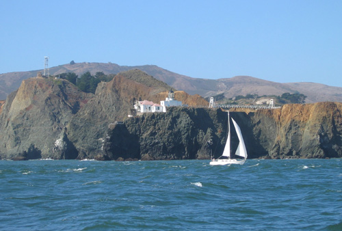 The Point Bonita Lighthouse was constructed in 1855 and was moved to its current location in 1877where it guards the northern entrance to the Golden Gate. It was the third lighthouse to be built on the West Coast following Alcatraz and Fort Point. Point Bonita is still an active lighthouse maintained by the United States Coast Guard. The Point Bonita Lighthouse was constructed in 1855 and was moved to its current location in 1877where it guards the northern entrance to the Golden Gate. It was the third lighthouse to be built on the West Coast following Alcatraz and Fort Point. Point Bonita is still an active lighthouse maintained by the United States Coast Guard.
The shoals of the San Francisco bar build huge seas particularly when an ebb current flows under the span and meets the waves traveling over the Pacific. Potato Patch is part of the "Four Fathom Shoal" covering several square miles just outside Point Bonita on the north side of the channel and is reportedly named for a barge load of potatoes lost from the decks while crossing this shoal.
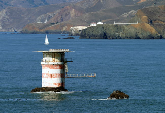
Mile Rock is the site of the lighthouse at the southern side of the channel leading through the Golden Gate and lies just about a mile from the channel. The current platform was once topped by a slender tower, telescoping in smaller white cylinders for three levels and was capped by a black lantern room.The whole thing was built by sailors recruited from the waterfront because normal construction workers refused. Their main concern was the commute: the structure was built on a small barnacle covered rock just forty feet long and thirty feet wide. Workers had to jump from a small boat to the work site amongst the often rough seas and often ended up in the water. In the 1960's the top half was removed by the Coast Guard leaving a helipad. In another brilliant move, they tried to remove the fog horn in the 1990's but were overruled by people of the Sunset district of San Francisco who missed its mournful sound.
Farallon Islands
 The islands were long known to the American Indians who lived in the Bay Area prior to the arrival of Europeans, but they are not thought to have traveled to them. The first European to record the islands was the English privateer Sir Francis Drake, who landed on the islands on 24 July 1579, in order to collect seal meat and bird eggs for his ship. He named them the Islands of Saint James, a name that survives only as the name of one of the rocky islets of the North Farallones. The islands were given the name "Farallones" (literally 'Rocks') by Sebastián Vizcaíno, who first charted them in 1603
.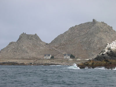 Beginning in 1853, a lighthouse was constructed. As the city grew, the seabird colonies came under severe threat as eggs were collected in the millions for the markets of San Francisco. The trade, which in its heyday could yield 500,000 eggs a month, was the source of conflict between the egg collecting companies and the lighthouse keepers. This conflict turned violent in a confrontation between rival companies in 1863. The clash between two rival companies, known as the Egg War, left two men dead and marked the end of private companies on the islands, although the lighthouse keepers continued egging. This activity, combined with the threat of oil spills from shipping in San Francisco's shipping lanes, prompted President Theodore Roosevelt to sign Executive Order No. 1043 in 1909, creating the Farallon Reservation, protecting the northern islands of the chain Coast Beginning in 1853, a lighthouse was constructed. As the city grew, the seabird colonies came under severe threat as eggs were collected in the millions for the markets of San Francisco. The trade, which in its heyday could yield 500,000 eggs a month, was the source of conflict between the egg collecting companies and the lighthouse keepers. This conflict turned violent in a confrontation between rival companies in 1863. The clash between two rival companies, known as the Egg War, left two men dead and marked the end of private companies on the islands, although the lighthouse keepers continued egging. This activity, combined with the threat of oil spills from shipping in San Francisco's shipping lanes, prompted President Theodore Roosevelt to sign Executive Order No. 1043 in 1909, creating the Farallon Reservation, protecting the northern islands of the chain Coast
The islands are the site of many shipwrecks, including the liberty ship SS Henry Bergh, a converted troop carrier that hit West End in 1944, pieces of which can still be seen from the island today (all hands were saved).From 1945 to 1970 the sea around the Farallones was used as a nuclear dumping ground for radioactive waste. The USS Independence used as a target in Bikini Atoll nuclear tests is said to have been sunk at this site. The United States Coast Guard maintained a manned lighthouse until 1972, when it was automated. A research station on the island is supplied and serviced by volunteers who bring those whose research jobs give them permission to land. All others must stay away. The islands are also the offshore target of the annual Farallon Race which has caused quite a few wrecks on its own.
 Spain fortified the high white cliff at the narrowest part of the bay's entrance, where Fort Point now stands. The Castillo de San Joaquin, built in 1794, was an adobe structure housing nine to thirteen cannon. The little fortress guarded the Spanish colony until 1821, when Mexico won independence from Spain. After independence, the Mexican army moved to Sonoma and when, on July 1, 1846), John Charles Fremont, along with Kit Carson and a band of 10 followers, stormed the castillo and spiked the cannons, they discovered that the fortress was empty. After victory in the Mexican American war, gold was discovered and the Yankee population of California skyrocketed and it became more important to keep California out of the Civil War. The U.S. Army Corps of Engineers began work on Fort Point in 1853. Plans specified that the lowest tier of artillery be as close as possible to water level so cannonballs could ricochet across the water's surface to hit enemy ships at the water-line. Workers blasted the 90-foot cliff down to 15 feet above sea level. The structure featured seven-foot-thick walls and multi-tiered casemated construction typical of Third System forts. It was sited to defend the maximum amount of harbor area. While there were more than 30 such forts on the East Coast, Fort Point was the only one on the West Coast. Spain fortified the high white cliff at the narrowest part of the bay's entrance, where Fort Point now stands. The Castillo de San Joaquin, built in 1794, was an adobe structure housing nine to thirteen cannon. The little fortress guarded the Spanish colony until 1821, when Mexico won independence from Spain. After independence, the Mexican army moved to Sonoma and when, on July 1, 1846), John Charles Fremont, along with Kit Carson and a band of 10 followers, stormed the castillo and spiked the cannons, they discovered that the fortress was empty. After victory in the Mexican American war, gold was discovered and the Yankee population of California skyrocketed and it became more important to keep California out of the Civil War. The U.S. Army Corps of Engineers began work on Fort Point in 1853. Plans specified that the lowest tier of artillery be as close as possible to water level so cannonballs could ricochet across the water's surface to hit enemy ships at the water-line. Workers blasted the 90-foot cliff down to 15 feet above sea level. The structure featured seven-foot-thick walls and multi-tiered casemated construction typical of Third System forts. It was sited to defend the maximum amount of harbor area. While there were more than 30 such forts on the East Coast, Fort Point was the only one on the West Coast.
The original lighthouse (completed just after the one on alcatraz) was razed after only three months in favor of the fort construction The fresnel lens slated for the site was diverted to Point Pinos where it still exists. The second lighthouse was in a wooden tower which succumbed to wave action after only eight years.
The third Fort Point lighthouse was built in 1864. The
27-foot iron tower was built on the roof of the fort, placing
it 83 feet above sea level. The tower was white with a black
lantern room, and a black iron spiral staircase to the
tower. The tower housed a fourth-order lens. This tower
still stands today although the need for the lighthouse dimmed after construction of the bridge (which obscured the light) and operation was discontinued in 1934.
The fort survived the earthquake off 1906 and remained in use through WWII when soldiers were stationed here to man the anti-submarine nets stretching across the bay.
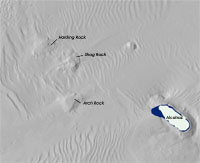 Underwater rocks in Central San Francisco Bay have been a problem since the British Navy sloop "Blossom" Underwater rocks in Central San Francisco Bay have been a problem since the British Navy sloop "Blossom" encountered Blossom Rock in 1826. Blossom Rock, Harding Rock, Arch Rock and Shag Rocks have been modified several times by dynamite.
From 1867 to 1869, Blosswom Rock was reduced from approximate elevation of -5' MLLW to -24' MLLW. At the beginning of the 1900's, Blossom Rock, Arch Rock, and Shag Rocks had their tops removed to a depth below -30' MLLW. Again in the 30's Arch Rock and Shag Rocks had their tops removed to a depth below -35' MLLW and Blossom Rock was lowereed to -40 MLLW. They still pose a hazard to deep draft shipping as these underwater rock masses extend above -40' elevation referenced to mean lower low water and their are current proposals for more blasting. encountered Blossom Rock in 1826. Blossom Rock, Harding Rock, Arch Rock and Shag Rocks have been modified several times by dynamite.
From 1867 to 1869, Blosswom Rock was reduced from approximate elevation of -5' MLLW to -24' MLLW. At the beginning of the 1900's, Blossom Rock, Arch Rock, and Shag Rocks had their tops removed to a depth below -30' MLLW. Again in the 30's Arch Rock and Shag Rocks had their tops removed to a depth below -35' MLLW and Blossom Rock was lowereed to -40 MLLW. They still pose a hazard to deep draft shipping as these underwater rock masses extend above -40' elevation referenced to mean lower low water and their are current proposals for more blasting.
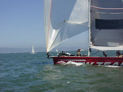 The area just inside the bridge and between Alcatraz and Angel Islands to the Berkeley Pier is known as "the Slot" and the winds whipping around Point Blunt on Angel Island often reach 30+ knots. Great Stuff. This is the area where multiple races are held and multiple spinnakers are blown out Through this narrow channel must pass all the container traffic and tanker traffic entering or leaving the bay. Windsurfers love the waves and winds right in close to the South Tower and tourist ferries run out under the bridge. Deep water traffic is under control of the VTS which can be monitored on channel 14 and their jargon can be interpreted with help here. The racing schedules and many of the race buoys are administered by the Yacht Racing Association of San Francisco Bay. and race schedules are available here. The area just inside the bridge and between Alcatraz and Angel Islands to the Berkeley Pier is known as "the Slot" and the winds whipping around Point Blunt on Angel Island often reach 30+ knots. Great Stuff. This is the area where multiple races are held and multiple spinnakers are blown out Through this narrow channel must pass all the container traffic and tanker traffic entering or leaving the bay. Windsurfers love the waves and winds right in close to the South Tower and tourist ferries run out under the bridge. Deep water traffic is under control of the VTS which can be monitored on channel 14 and their jargon can be interpreted with help here. The racing schedules and many of the race buoys are administered by the Yacht Racing Association of San Francisco Bay. and race schedules are available here.
|
|